
What are satellite data embeddings and why are they needed
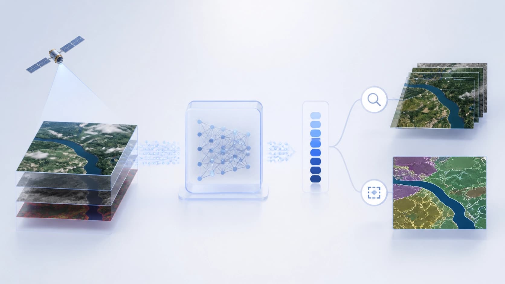
Satellite imagery is not just pictures, but multidimensional data: spectral bands, polarization, time series. Working with them directly is difficult: a model can get lost in noise, and analysts need to quickly compare large areas. This is where embeddings come in — compact vector representations that compress the essence of a scene into a numerical vector. Such vectors can be compared, clustered, and used as features for machine learning.
OlmoEarth embeddings are built by open foundation models trained on Earth observation data. Their key feature is that the source code and weights are publicly available — anyone can verify exactly how a vector was produced and, if necessary, reproduce the computation themselves. This adds trust and flexibility: the result is not a "black box."
How OlmoEarth embeddings work
What is OlmoEarth Studio
OlmoEarth Studio is a service where you can compute embeddings for a selected area of the Earth's surface and export them as ready-to-use files. Instead of a pre-built global archive of vectors, the studio computes embeddings on demand, tailored to specific conditions. This means you can get imagery for a specific month or season rather than settling for an averaged picture.
What parameters can be set
When launching computations, the user specifies several parameters:
- Area of interest — a polygon that defines the territory for analysis.
- Time range — from one to twelve months.
- Encoder variant — the model that turns imagery into vectors. Three options are available: Nano (128 dimensions, 1.4M parameters), Tiny (192 dimensions, 6.2M parameters), and Base (768 dimensions, 89M parameters). The larger the model, the richer the representation, but also the higher the computational requirements.
- Resolution — 10, 20, 40, or 80 meters per pixel. The choice depends on the scale of the task: fine resolution suits point-level analysis, while coarse resolution works for regional surveys.
- Imagery sources — Sentinel-2 L2A, Sentinel-1 RTC, or both. The former provides optical data, the latter radar data.
All these settings are available both through the graphical interface and via the API, so the process can be easily integrated into automated pipelines.
How to export embeddings from Studio
The process of obtaining embeddings in OlmoEarth Studio works just like a standard prediction workflow: first, the model is configured and run, then the results are downloaded. No additional export steps are required.
Output data format
The results are saved as Cloud-Optimized GeoTIFF (COG) — a format optimized for cloud storage and streaming. Inside the file, one band corresponds to one embedding dimension. For example, for the Tiny model this means 192 bands — each with its own numerical value.
The values are stored in a compact form — as signed 8-bit integers ranging from −127 to +127. A special value of −128 is reserved for missing data (nodata). This encoding significantly reduces file size, but analysis may require restoring the original float vectors. For this purpose, the dequantize_embeddings function is provided in the olmoearth_pretrain package — it converts integer values back to fractional ones.
Access to the service
To export custom embeddings via Studio, you need to request access to this feature. For those who want to compute vectors on their own without waiting for access, public models are available — instructions for running them are published in the project documentation.
Applications of embeddings in analysis
The main value of embeddings is that they turn raw satellite data into convenient features that can be used to solve practical tasks without labor-intensive labeling of large datasets.
Similarity search
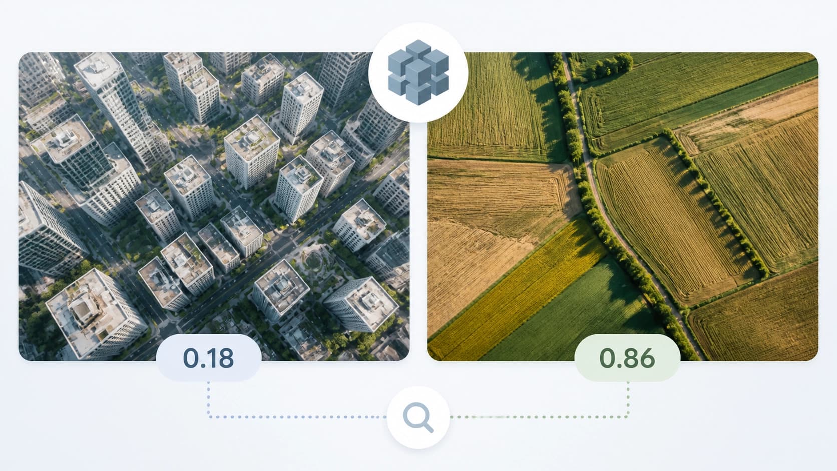
By comparing vectors with each other, you can find areas similar to a given reference. For example, in a test case with the OlmoEarth-v1-Tiny model (192 dimensions, 40-meter resolution, Sentinel-2 L2A), urban development was successfully separated from agricultural land without a single labeled sample. You simply set a query vector, and cosine similarity shows which areas are most similar to it and which are fundamentally different.
This approach is useful for rapid territory inventory: anomaly detection, classification of landscape types against a reference, and checking changes between seasons.
Few-shot segmentation
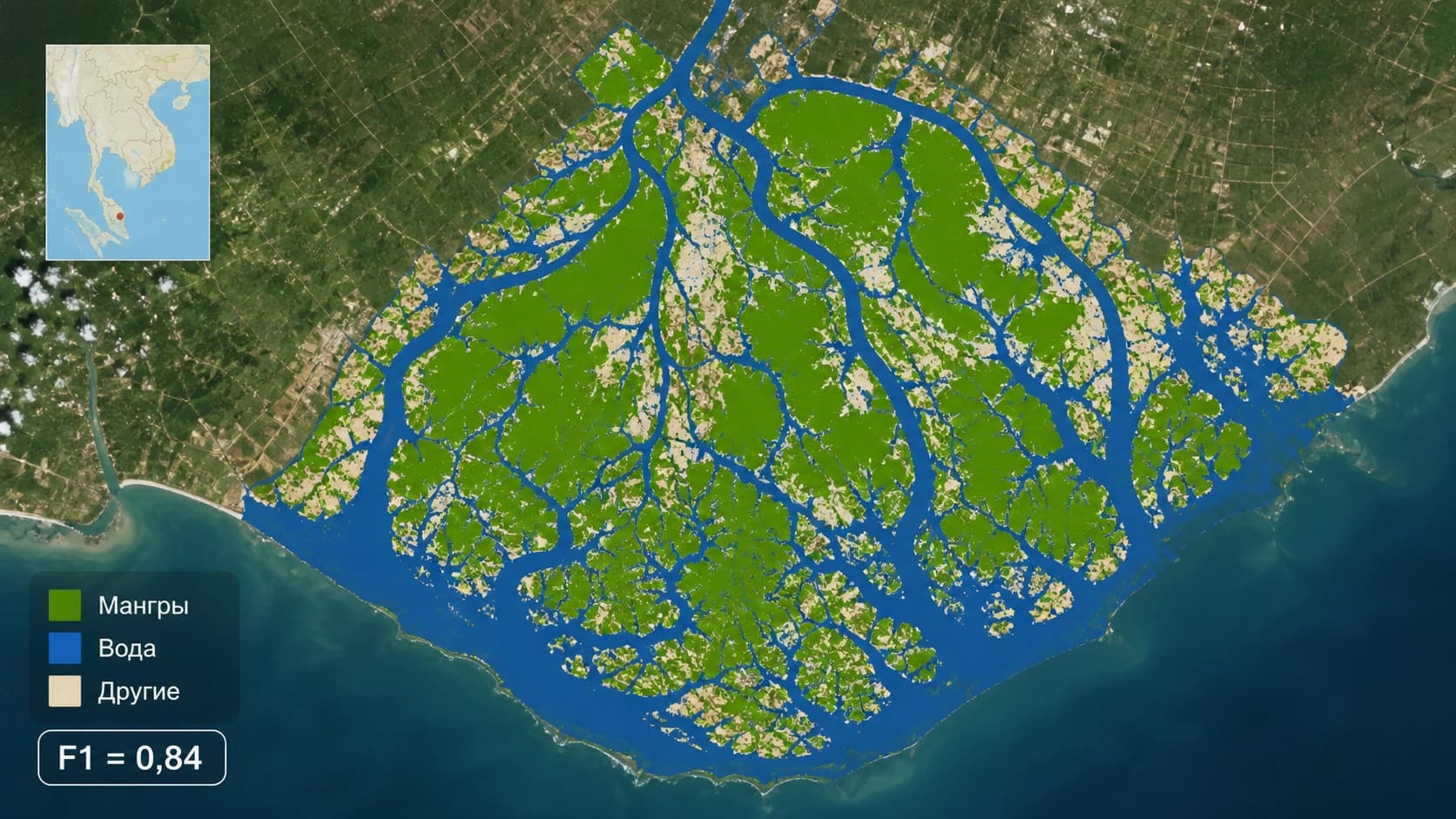
Embeddings also perform well in tasks with limited labeling. In an experiment in Ca Mau (Vietnam), researchers used a linear classifier trained on just 60 labeled pixels — 20 for each of three classes: mangrove forests, water, and other land. The weighted F1-score reached 0.84, which is quite respectable for such a modest training set. Notably, increasing the number of labels from 30 to 300 barely changed accuracy — meaning embeddings already contain enough information for the model to quickly reach a plateau.
This makes the approach attractive for projects where expertise is expensive or the territory is hard to access: instead of thousands of labeled pixels, dozens are enough.